
26 May 2026INFO | paragliding
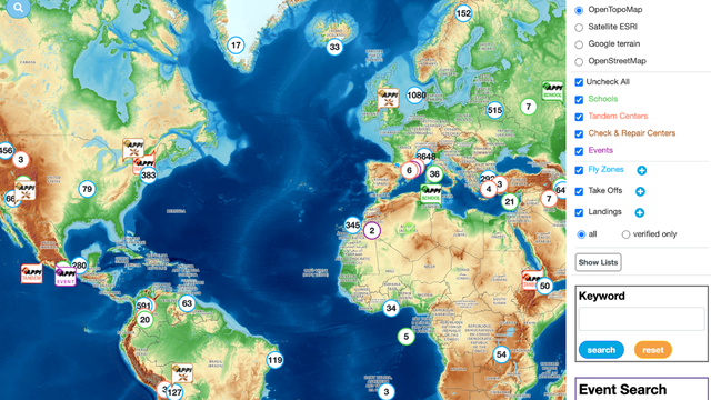
We are delighted to announce that our APPI worldwide map now includes flight zone mapping. The goal is to build a reliable international map with data verified and approved by the APPI community.
To populate this map, we collected data available on the web. Imported take-offs and landings appear with faded icons and have the status "imported". These elements are not meant to remain permanently — the reliability of this data is generally average, and they serve as a starting point.
Updating and verifying take-offs and landings
When an APPI member edits a take-off ✅ or a landing 🔴, they appear with a vivid icon and the status "verified". To edit them, simply click the small blue pencil icon at the top of the sheet.
This is an opportunity to update the description, rules, access, and general weather information, and optionally refine the location. You can also fill in the activities practiced as well as the optimal and acceptable orientations. For take-offs accessible by hiking, it is possible to upload the GPX track. If the take-off or landing is subject to restrictions (occasional or recurring), this can be mentioned. A warning icon will then appear on the map during these periods. You can also add a few photos and a presentation video, and rate the accessibility from easy to difficult on 5 levels.
A new concept: flight zones
The new feature in APPI is the concept of flight zones. You can define flight zones by linking take-offs and landings to them, which provides a synthetic overview of the possibilities in a given area. It is within the flight zone that you can enter the contacts of local managers, schools, and clubs, as well as all general information about the zone.
On the map, flight zones appear as blue circles encompassing the associated take-offs and landings. The extent of flight zones is limited to 100 km in diameter.
Of course, if you know of any take-offs, landings, or flight zones not yet listed, you can create them by clicking the blue + in the legend on the right side of the map.
Using the feature as a visitor
As a simple visitor, you can of course browse all this information, leave comments on a flight zone, take-off, or landing (small chat), and rate the reliability and accuracy of the information. With one click, you can also access the flight tracks recorded in the area.
Together with the APPI community, let's build the world's most reliable flight zone database!
thumbnails


